Friday, June 28, 2013

A Tale of Two Conglomerates: Chapter 1

A name should tell you something.  When it comes to rocks this is generally the case.  In sedimentary rocks, the name tends to give away the energy of the sedimentary environment.  Sandstone forms wherever sand might gather - like a beach with strong waves or a fast moving stream.  Shale evolves where clay might gather, say the bottom of the ocean.  Conglomerate, along similar lines, is birthed where gravel collects - perhaps a raging river or a bar in a particularly active part of the ocean.  The name conglomerate tells you that there was enough energy to carry rocks there, but the rock tells you a lot more.

Last summer I visited two conglomerate outcrops; one was Mount Battie in Camden, the other Mars Hill Mountain in Mars Hill.  These two rocks couldn't be any different while sharing the same name.  Each rock tells this history of its own place in three distinct chapters.

Chapter 1: Clasts
Mount Battie Conglomerate - Round Quartzite Clasts Circled
One neat thing about conglomerates is there are two sets of rocks with stories to tell: the conglomerate itself, and the rocks parts that are cemented together within it.  The rock parts (or in geology speak, clasts) at the two sites are surely at odds.  The Mount Battie conglomerate is made up of rounded, light colored clasts about the size and appearance of a pale gray gumdrop.  The gumdrops are quartzite.  If we could turn back the clock we would see that these chunks (like all quartzite) were once sandstone.  Imagine a wave rocked ocean off the coast of some forgotten continent.  Sand piles up (pure sand; we know this because the quartzite is so light in color) and eventually, chemical intrusion turns it from packed sand to sandstone.  Once loose sand, now solid rock, as they say, even this shall pass.  Perhaps the land gets raised and rivers cut through.  The slab of rock, once a beach, is broken by time and water into smaller pieces.  As the water courses the rocks get rounder and rounder.


Mars Hill Conglomerate - Flat Black Clasts Squared, Jagged
Edge Visible on Top Piece
Mars Hill has a different story.  The rocks that comprise this conglomerate are flat and black.  The flatness (and perhaps the darkness) suggests that this rock may be a shale formed in a  low energy environment.  This rock probably sat at the bottom of some ocean.  Layer upon layer of fine-grained sediment coasted to the seafloor at a ridiculously slow pace, with added phytoplankton and low oxygen levels coloring the sediment black.  Here too the land becomes elevated.  Streams shatter the shale and push it downstream.  The current softens the edges a bit before the slivers of rock reach an endpoint.

The endpoint, however is just an endpoint, not the end.  The beach, the ocean bottom, they are just the first step in the stories told by these rocks.  Check back soon for chapter 2 and 3.

Dietrich, Richard Vincent, and Brian J. Skinner. Rocks and Rock Minerals. New York: Wiley, 1979. Print.

Way, Bryan. "Black Shales." 1 Dec. 2006. Web. 28 June 2013. <http://faculty.umf.maine.edu/eastler/public.www/Black%20Shales.pdf>.


Monday, June 24, 2013

The Geology Hikes Map

The predecessor to the Maine Geology Hikes Blog, was the Geology Hikes in Maine Map.  At this point there are 14 locations with brief geology stories for each icon.  Recently, I've linked blog entries relevant to a few places in their icons.  Feel free to peruse the map as it is now, but I'd also like to add new sites to the map as well.

Specifically, I'd like to update it with places you plan to visit.  Over the next week list places you are thinking of hiking here in the comments or on the Maine Geology Hikes Facebook page and I will write a brief description of the geology of the location to which you will be going.  Disclaimer: I probably won't be able to ground truth many locations before next weekend, so the descriptions will be based on research at a distance.  I'll respond to your suggestions in the comments and include new red icons on the Geology Hikes in Maine Map.  The locations will remain in red until I can ground truth them.

Some notes 1) Your location needs to be in Maine,  2)You'll be able to see more of the geologic history if it is a rocky location, 3) Include some detail about the location so I can find it on maps.  Consider including the town it is in, the road you will be entering from, or a link to a trail description.


View Geology Hikes in Maine in a larger map

Friday, June 21, 2013

Maine's Earthquakes

Today there was a small earthquake about 7 miles from Augusta Maine.  The quake was a 2.6 on the Richter Scale.  Because the Richter scale is logarithmic, each point it rises means the quake is 10 times stronger.  By extension, this quake was about 100 times gentler than the 4.5 that many of us in southern Maine felt last October 16th.

We're used to hearing about big earthquakes: The 2010 Haiti earthquake (7.0), the 2011 Japan earthquake (9.5, 10,000,000 times as powerful as the one felt today) or the ones that occur along the San Andreas in California.  All of these occur on active plate boundaries where one plate is shoving under or, in the case of California, past another, but what's happening in Maine?  There haven't been any active plate boundaries in Maine for more than 200 million years.

If you could look at Maine's Carfax report it would not look good.  Maine is the victim, nay product, of several collisions with other landmasses.  Each one left Maine with several small faults, where the old continents docked.  Then there was the stretching.  When Pangaea split the continent spread to fill up the old space.  Some parts of once solid rock sank down, while others remained aloft.  The result: despite it's beautiful exterior, our state has some pretty severe internal damage.

There are faults on the surface within 15 miles of today's earthquake, but the earthquake occurred 3.1 miles underground.  It's difficult to assign blame for the earth shift that occurred, but we can be assured that it is a result of Maine's storied tectonic history.

"Central Maine Feels 2.6 Magnitude Earthquake." Bangor Daily News. 21 June 2013. Web. 21 June 2013. <http://bangordailynews.com/2013/06/21/news/state/central-maine-feels-2-6-magnitude-earthquake-sidney/>.

"M2.6 - 2km W of Sidney, Maine." Earthquake Hazards Program. United States Geological Survey, 21 June 2013. Web. 21 June 2013. <http://earthquake.usgs.gov/earthquakes/eventpage/usc000hx15#summary>.

"Maine Earthquakes 1997 to Present." Maine Geological Survey. State of Maine. Web. 21 June 2013. <http://www.maine.gov/doc/nrimc/mgs/explore/hazards/quake/quake-recent.htm>.

Wednesday, June 19, 2013

The Long View: Watching the Earth Move

It surprised me when I read that you could see Mount Washington from a hilltop in Falmouth, so when I climbed Stone Ridge, I was impressed with the amazing view.  My first visit on a clear day in April gave me a Kodachrome view of the mountain and the broad landscape between here and there.  It wasn't until much later that I realized that this might just be the perfect perch from which to watch the earth move.

Of course the White Mountains were just the starting point (well, really Mount Royal in Montreal, Canada, but you can't see that far).  One hundred eighty million years ago there was a hot spot under what would one day become eastern New Hampshire.  In geology, a hot spot is a thin stream of Earth's heated innards bubbling up towards the surface over a long period of time.  When the hot spot underlies a continent the result is violent, explosive eruptions at the surface.  These eruptions and the super-heated magma below the surface built the White Mountains over twelve million years.

The hot spot never moved, and it never stopped bubbling.  The good news for the residents of North Conway, is that New Hampshire did.  When Pangaea split apart, opening the Atlantic Ocean, North America pushed westward, and Africa pushed (relatively) eastward.  By one hundred twelve million years the continent had moved to the point that the hot spot underlay Denmark, Maine, building Pleasant Mountain.  By one hundred eight million the Earth was bubbling in Brownfield, forming Burnt Meadow Mountain.  

The View from Stone Ridge in Falmouth.  Burnt Meadow Mountain is in the center, the White Mountains on the right, and Pleasant Mountain in between.  All are highlighted in red. (a lot of time on Google Earth may not have made up for poor spatial ability; leave comments if you think I've misidentified the mountains).
Soon after the North American continent escaped the fiery clutches of the hot spot, but the hot spot didn't quit.  Between 100 and 75 million years ago it left a trail of underwater mountains (called seamounts) stretching from the continental shelf to the mid-ocean ridge.  At that point, the seamounts seem to sputter out, that is until they emerged on the opposite side of the ridge, where as recently as 10 million years ago they appeared to be approaching Africa and the Canary Islands (or really Africa was approaching the hot spot).

Of course we can't see all of that from Falmouth, but we can see a few million years of continental progress, before the horizon shades our view.  On a clear day, the White Mountains are visible and Pleasant and Burnt Meadow Mountain can be seen as well.  The picture provides not just beautiful scenery, but a window into the tectonic motion that occurs over millions of years.

"Science Reference: Hotspot (geology)." ScienceDaily. ScienceDaily. Web. 19 June 2013. <http://www.sciencedaily.com/articles/h/hotspot_(geology).htm>.

Girty, G. H. "Chapter 2: Volcanoes." Perilous Earth: Understanding Processes Behind Natural Disasters. Department of Geological Sciences, San Diego State University, June 2009. Web. 1 June 2013.<http://www.geology.sdsu.edu/visualgeology/naturaldisasters/Chapters/Chapter2Volcanoes.pdf>.

Watling, Les. "Geological Origin of the New England Seamount Chain." NOAA Ocean Explorer Podcast RSS. Web. 19 June 2013 <http://oceanexplorer.noaa.gov/explorations/03mountains/background/geology/geology.html>.

Zartman, R. E. "Geochronology of Some Alkalic Rock Provinces in Eastern and Central United States." Annual Review of Earth and Planetary Sciences 5.1 (1977): 257-86.

Friday, June 14, 2013

Resources: Identifying Rocks

The rock identification guide I have is an excellent resource.  It has beautiful pictures, detailed descriptions and it is well organized, but it is easy to be overwhelmed by minutia and jargon. With words and phrases like hexagonal dipyramidal, sphalerite  and chlorite-amphibole-epidote-albite schist, one can feel tempted to not event try to learn.

There are a few great online resources to assist beginners in the identification of rocks.  If you want to try, check out these to sources:

The Rock Key at rockhounds.com - This site has an clear dichotomous key, which helps you select the correct rock by making a series of either/ or choices.  Some of the steps require advanced equipment like a nail or piece of glass, but you can figure most of it out by just looking at the rock and clicking through.  There is good introductory material at the top of the page, and good synopses of the rock types down below.

Rock Galleries at geology.about.com - Sometimes it can be easier to get visual affirmation of the rock type and for that purpose these galleries are a great start.  Once you have determined the type of rock (igneous, sedimentary or metamorphic) these galleries have clear pictures of rocks in one location.

Of course these are just a couple resources.  If you know of others or have questions about how to use these please leave comments.

Tuesday, June 11, 2013

A Piece of Bradbury: Rebel Pegmatite

Some things in this world are predictable.  There is a very clear relationship between how big the crystals in an igneous rock are, and how long it took to form.  But some rocks rebel.

The rule of igneous rocks is simple. If crystals are small - as in a piece of basalt or rhyolite - the rock froze fairly quickly, having risen to the Earth's surface before dropping in temperature rapidly.  If the crystals are large, as is the case of this piece of granite I found at Bradbury Mountain, it means the rock formed deep underground, where the heat of the Earth allowed each crystal to gestate to full visible size before turning fully solid.
The rock that makes up Bradbury Mountain formed as Africa shoved its way underneath the North American plate - squeezing magma into Maine's underbelly.  Of course at that point the rock was covered with a thick blanket of rock thrown up by earlier parts of the collision.  The magma cooled slowly, and the crystals grew to the size you now see, following the rule to a tee.

Turn the rock around however, and you find these rebels, younger crystals, forming faster and larger than their granite brothers and sisters.  These crystals are pegmatite, effectively a large crystalled rock with the same make up as the granite on the reverse.  Pegmatite drew people to the site in the 1920s because the large crystals of the mineral feldspar were easily gathered for making ceramics.  But how did it get there?

As it solidified, the mass of magma that had squeezed under Maine, shriveled like a raisin.  The contraction created a gap with the surrounding rock, as well as spiderweb of cracks near the edge of the hardening granite.  These became a network of passageways through which left over magma could flow.  The remaining magma had all of the components of the original, but with a higher concentration of materials that couldn't form minerals, among others water.  This extra stuff became a super serum for crystal growth, filling in the empty space with megacrystals, a hundred times the size of their brethren.


Landes, Kenneth K. "The Paragenesis of the Granite Pegmatites of Central Maine."American Mineralogist 10 (1925): 355-411.

London, David. "Granitic Pegmatites: An Assessment of Current Concepts and Directions for the Future." Lithos 80 (2005): 281-303.

Simmons, Skip. "Pegmatite Genesis: Recent Advances and Areasfor Future Research." Proc. of Granitic Pegmatites: The State of the Art – International Symposium, Porto, Portugal. Web. 11 June 2013. <http://www.fc.up.pt/peg2007/files/simmons.pdf>.

Zieg, M. J., and B. D. Marsh. "Crystal Size Distributions and Scaling Laws in the Quantification of Igneous Textures." Journal of Petrology 43.1 (2002): 85-101.

"Bradbury Mountain State Park." Maine Bureau of Parks & Lands. 2009. Web. 10 June 2013. <http://www.maine.gov/cgi-bin/online/doc/parksearch/search_name.pl?state_park=12>.


Sunday, June 2, 2013

Mount Agamenticus: Maine's Kilimanjaro

Mount Kilimanjaro, Earth's highest free-standing peak, projects nearly 20,000 feet into the African sky, towering above the plains and valleys below.  Mount Agamenticus projects as well, but to a decidedly lesser 700 feet. Despite the clear difference in stature, the two mountains have a lot in common.

Mount Kilimanjaro Dec 2009
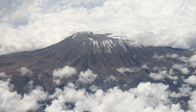
Mount Kilimanjaro in the Distance
The East African Rift Valley is slowly growing wider, tearing the African continent apart at the Earth's seam.  At its center the warm interior of the Earth rises to the surface, creating a wending line of volcanoes that stretches from the Red Sea in the North to Lake Malawi in the south. The upwelling magma creates pressure that pushes the parts of the continents away from the spreading center.

It is a Mole Hill:  Mount Agamenticus from Kennebunkport Shore
Mount Agamenticus in the Distance
As a rule, the eruptions of magma stick to that central path, but the volcanoes are a little more unruly than the general might suggest. Along the rift, magma has three options. First, it can ooze out of vents, forming thin dikes. Second pure rift magma can create broad, gently sloped mountains called shield volcanoes.  Finally, rift magma can melt and mix with other rock to spawn energetic explosive eruptions that pile up magma and ash into tall steep sided sentries that sit beside the rift called stratovolcanoes.  Kilimanjaro obviously fits into this third category along with Mount Kenya (in Kenya) and Mount Meru (in Tanzania).

Actually, so does Mount Agamenticus, right here in Maine.  Or at least it did. Mount Kilimanjaro started to form about 2.5 million years ago, and its last eruption occurred about 175,000 years ago. While this may be a long time on a human scale, on a geologic scale Kilimanjaro is a young Turk.  Imagine Agamenticus on a similar boundary two hundred million years ago: the Maine coast is bidding a fond adieu to the North African shoreline after a short tryst as Pangea and Agamenticus rises 20,000 feet above the western coast. The volcanic center of this rift valley is widening and filling with the water that will someday become the Atlantic Ocean.  As it does, streams and ice begin the shortening process of our once giant sentinel.  Fast forward a hundred million years - the mountain is smaller, the ocean wider and about halfway to the form we now see.  One hundred million more and the mountain is little more than 1/30th its former height, the spreading center nearly 1500 miles away.  

Bloom, Arthur L. Geomorphology: A Systematic Analysis of Late Cenozoic Landforms. Upper Saddle River, NJ: Prentice Hall, 1998. Print.

Brooks, John A., Gust, David A., and Hussey, Arthur M., II, 1989, The geology and geochemistry of the Agamenticus Complex, York, Maine; in Berry, Archie W. (editor), Guidebook for field trips in southern and west-central Maine: New England Intercollegiate Geological Conference, 81st Annual Meeting, October 13-15, 1989, University of Maine at Farmington, Maine, p. 1-24

Byran, Wilfred B. "The Mount Agamenticus Conservation Region -." Geology of Mt. A. The Mount Agamenticus Conservation Region. Web. 02 June 2013. <http://www.agamenticus.org/index.php/geology-of-mt-a>.

Girty, G. H. "Chapter 2: Volcanoes." Perilous Earth: Understanding Processes Behind Natural Disasters. Department of Geological Sciences, San Diego State University, June 2009. Web. 1 June 2013. <http://www.geology.sdsu.edu/visualgeology/naturaldisasters/Chapters/Chapter2Volcanoes.pdf>.

Nonnotte, Philippe, HervĂ© Guillou, Bernard Le Gall, Mathieu Benoit, Joseph Cotten, and StĂ©phane Scaillet. "New K–Ar Age Determinations of Kilimanjaro Volcano in the North Tanzanian Diverging Rift, East Africa." Journal of Volcanology and Geothermal Research 173.1-2 (2008): 99-112.